Wyoming Word Cloud
Word Cloud > Wyoming
Wyoming Information
Fur traders moved to Wyoming in the early 19th century. Later, settlers followed along the Oregon trail. Wyoming's economy is mainly based on agriculture. It does, however, have large surface coal mines. Wyoming attracts tourists for fishing, hunting, rodeos, and scenery. Wyoming became the 44th state in 1890.Authored by jeh. Last updated 2015-08-18 18:51:17.
- Wyoming Map
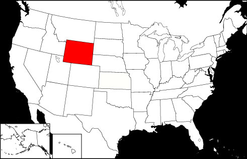
Wyoming is the 9th largest USA state, bordered by Montana, Colorado, Idaho, South Dakota, Nebraska, and Utah. Visit this site to learn more and find printable road maps and topo maps of Wyoming.
www.state-maps.org/wyoming-map/ - Wyoming Directory
Learn about Wyoming's demographics and economy, and use the Categories Menu to find businesses and other organizations in Wyoming.
www.regionaldirectory.us/wyoming.htm - Wyoming Real Estate Guide
Learn about urban, suburban, and rural real estate markets in Wyoming. Real estate agents, buyers, and sellers will appreciate the Wyoming real estate resources on this page.
www.local-real-estate.com/wyoming.htm - Wyoming Atlas
Wyoming state history, geography, and travel information are the subjects of this Wyoming atlas page.
www.onlineatlas.us/wy.htm  Wyoming Road Map (Illustration)
This Wyoming map page comprises a detailed, scalable road map of Wyoming, as well as Interstate highway information, scenic road highlights, and state road and transport links.
www.state-maps.org/wyoming-map/road-map.htm- Devil's Tower, Wyoming (Photograph)
Captioned gallery photo and description of the Devil's Tower National Monument in northeastern Wyoming.
www.onlineatlas.us/gallery/devils-tower.htm - Idaho Map
Idaho is the 11th largest state in the USA, surrounded by the Canadian Province of British Columbia and the states of Nevada, Wyoming, Montana, Utah, Washington, and Oregon.
www.state-maps.org/idaho-map/ - Montana Map
Montana is the 4th largest state in the USA, bordered by North Dakota, South Dakota, Wyoming, Idaho, and the Canadian Provinces of Alberta, Saskatchewan, and British Columbia.
www.state-maps.org/montana-map/ - Nebraska Map
Nebraska is the 15th largest USA state, bordered by South Dakota, Kansas, Iowa, Wyoming, Missouri, and Colorado. Visit this site to learn more about Nebraska and find printable maps of the state.
www.state-maps.org/nebraska-map/ - South Dakota Map
South Dakota is the 16th largest USA state, bordered by North Dakota, Nebraska, Minnesota, Iowa, Montana, and Wyoming. Visit this site to learn more about South Dakota and find printable maps of the state.
www.state-maps.org/south-dakota-map/ - Utah Map
Utah is the 12th largest USA state, bordered by Arizona, Colorado, Nevada, Wyoming, and Utah. Visit this site to learn more and find printable road, topographical, relief, and regional maps of Utah.
www.state-maps.org/utah-map/ - Pinterest - Wyoming Board
This gallery page features selected Wyoming images, including the state flag, a locator map, and various travel photos.
www.pinterest.com/onlineatlas/wyoming/
Wyoming Directory Page(s)
- Wyoming Page on AbiReal.com
Visit this wyoming category page on abireal.com to find editorially-reviewed resources about this topic.
http://www.abireal.com/info/883/wyoming-map.html
- Wyoming Page on Adirectory.us
Visit this wyoming category page on adirectory.us to find editorially-reviewed resources about this topic.
https://www.adirectory.us/us-states/wyoming/
- Wyoming Page on GoGuides.org
Visit this wyoming category page on goguides.org to find editorially-reviewed resources about this topic.
http://www.goguides.org/topic/1627.html
- Wyoming Page on Jumblex.org
Visit this wyoming category page on jumblex.org to find editorially-reviewed resources about this topic.
http://en.jumblex.org/wyoming/
Wyoming News
- Irish woman's dream vacation to Wyoming horse ranch ended in painful disaster, lawsuit claims
Irish tourist Lorraine Learmont claimed her foot was 'irreversibly' shattered after a wrangler sprayed the horse she was riding with bear spray.
Daily Mail. Wed, 02 Apr 2025 17:35:09 GMT. - Republican grilled about DOGE at town hall: 'Where is this fraud?'
Wyoming Republican Rep. Harriet Hageman tangled with constituents at a fiery town hall in her home state on Thursday over Elon Musk's DOGE.
ABC News. Sat, 22 Mar 2025 23:10:33 -0400. - 3/14: CBS Evening News
American Airlines plane catches fire on tarmac of Denver airport after emergency landing; Alan Simpson, former Wyoming senator, dies at 93
CBS News. Mon, 17 Mar 2025 17:47:01 -0400.
Wyoming Image
 Wyoming Locator Map
Copyright © 2012-2025 Word-Cloud.org. All rights reserved.